Highway
20:
From Williams Lake
visitors may travel west for 455km (282 miles) through the Chilcotin
Plateau, over the Coast Mountains and down the Bella
Coola Hill to the Pacific Ocean. This scenic highway provides
much to see and do along the way. Enjoy the abundant fishing,
hiking,
horseback riding and white
water rafting here in this land of
adventure.
The
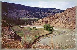
Junction Wildlife Management Area and Farwell Canyon:
Turn south 45km (28 miles) beyond
Williams Lake to visit this Wildlife
area which protects over 500 California bighorn
sheep. Farther down the road is Farwell Canyon where the Chilcotin
River cuts deeply into the clay and limestone cliffs. Visit the
pillar-like hoodoos, impressive sand dunes and Indian pictographs
of this unique area. Guided rafting trips are available to experience
the Chilcotin River rapids.
Tweedsmuir
Provincial Park:
36km (22 miles) west of
Anahim or 352km (218 miles) west of Williams Lake is the entrance
to B.C.'s largest Provincial Park. The majestic Tweedsmuir is a
wilderness park and incorporates only 54km (33.5 miles) of highway
within its boundaries.
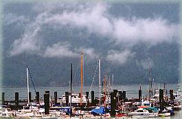
Hagensborg
& Bella Coola:
After descending down the famous 'hill' you will enter the Bella
Coola Valley. The village of Hagensborg was settled by Norwegians,
who were attracted by the fjords. Hwy 20 ends here in Bella Coola
at the head of North Bentinck Arm, an inlet of the Pacific Ocean.
In 1793 Alexander Mackenzie came overland to this area, while Captain
George Vancouver came by water.
The following BC Adventure members would like to serve you:
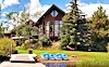
Eagle's Nest Resort: Beauty and comfort in the wilderness. Elegant suites or cozy log cabins. Lakeside dining room, breathtaking views, hiking and birdwatching, and the natural splendor of the area. more
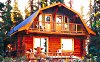
Escott Bay Resort: The adventure starts with fishing, hiking, horseback trail riding, pack trips and hunting – and with the snow comes x-country skiing & snowmobiling. Located between Tweedsmuir and Itcha Ilgachuz Parks, we offer fully serviced cabins and camping facilities. more