BC's On-Line  Hotel  Reservation System
Contents   The Kootenays

Google

The Kootenays
Lodging & Services
Recreation
Cities & Towns
Lakes

Travel Info
Points of Interest
Provincial Parks
Trails

Visit BC
Cariboo Chilcotin Coast
Northern BC
Rockies Kootenays
Thompson Okanagan
Vancouver & Coast
Vancouver Island

City Guides
BC Communities
BC Vacations
Fishing Vacations
Western Vacations
Eco-Adventures
Storm Watching
Ski Vacations

Golf Vacations
RV Vacations
Houseboat Vacations
Outdoor Adventures
Camping Expeditions
Guides & Outfitters
Guided Tours
Charters
Attractions
Events
Lodging
Search Lodgings
Hotels, Motels & B&Bs
Suites, Rentals & Condos
Wilderness Resorts
Saltwater Resorts
Guest Ranches
Health Spas, Hot Springs
Golf & Ski Resorts

Campgrounds & RV Parks
Add a Listing
Recreation
Search by Activity
Attractions

ATV
Boating
Camping
Canoe & Kayak
Dog Sledding
Fishing
Golf
Horseback Riding
Guided Tours
Health/Spas
Cat & Heli-Skiing
Hiking
House Boating
Mtn. Biking
Mtn. Climbing
Hot Springs
River Rafting

Scuba Diving
Skiing
Snowmobiling
Whale Watching
Fish BC
Saltwater Fishing
Lake Fishing
River Fishing
Fishing Vacations
Fishing Suppliers
BC Game Fish
Trophy Destinations
BC Fly Patterns
Entomology
Tips & Techniques
Travel Routes
Circle Tours
Maps
Points of Interest
Travel Logs
Brochure Rack
Browse
Trip Planner
Plan Your Vacation
Tourist Info

Special Events
 Road Reports
 Weather Reports
 Mileage Calculator
Coastal Ferry Info
Vancouver Airport
Transportation
BC Quick Facts
Customs
Currency
Taxes
Medical
Metric System
Motor Vehicles
Time Zones
Area Codes

Outdoors
Animals
Birds
Fish
Wildflowers
Trees
Survival
Parks
Trails

Wines of BC
BC Wines
Wineries
Wine Tours


Midway to Christina Lake

The Crowsnest Highway (Highway 3) leads from the South Okanagan through to Kootenay Country and the Rockies of British Columbia. Kootenay Country starts at Rock Creek, (52km or 32 miles east of Osoyoos). Continuing on you will pass through the Kettle Valley and Sawmill.

KV Rail MuseumMidway:
Midway between the Rockies and the Pacific Ocean, this small town is mainly a lumber town which started as a farming community.
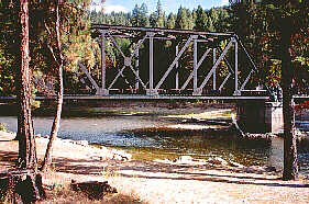
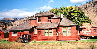
Kettle Valley Railway Station & Kettle River Museum:
Nearly a century old, this station is located on the outskirts of Midway. This was once the terminus of the Kettle Valley Railway (KVR). The KVR was completed in 1916 and is known as an engineering feat in railway history. The Kettle River Museum displays a few heritage buildings and train memorabilia.

Greenwood:
Located 16 km (10 miles) east of Midway is Greenwood. Several heritage buildings have been preserved including the McArthur Centre, Post Office, Sacred Heart Church and Parish House.

KV Rail BridgeGrand Forks:
Once a booming copper mining town, Grand Forks is located at the confluence of the Kettle and Granby Rivers. The ore from this area was shipped to the Granby copper smelter, the second largest in the world. History of wealthy copper mining production, the Doukhobors and farming in this fertile valley is evident along the walking tour possible here.

Mountain View Doukhobor Museum:
This 1912 Doukhobor communal farmhouse gives insight into their life style. More information at the Infocentre.

Christina Lake:
21 km (12 miles) from Grand Forks is this popular lakeside community. This thriving summer destination offers a recreation area as well as good fishing, boating and golfing.

Continuing past Christina Lake along Hwy 3 visitors will pass through a thick cedar, hemlock, fir, birch and forest. Further is the junction of Hwy 3B to the Nancy Greene Recreation Area then another 38 km (25 miles) to Trail.


Global Marketing Specialists

Advertise With Us

Promote your business to over 5.5 million BC visitors per year.
A
dvertise on the BC Adventure Network, British Columbia's largest and most visited tourism Web site . . . more info.


© 1995 - 2008 Interactive Broadcasting Corporation