Tete
Jaune Cache:
"Yellowhead" in French, Tete Juane Cache is located at the confluence
of the Fraser and Robson Rivers 266 km (165 miles) east of Prince George
off of Highway 16 and marks the easternmost part of the Northern
BC: Northwest & Hwy #16 region. Once a major construction center
during the building of the railway, this was once the head of navigation
for the flat-bottom stern wheelers which brought railway supplies up the
Fraser River.
McBride:
Situated in the fertile Robson Valley, 207 km (128 miles) east of Prince
George on the Yellowhead Highway 16 is the town of McBribe. Main economic
stays include agriculture and forestry. The area surrounding offers visitors
excellent fishing, canoeing,
kayaking, hiking
(including heli-hiking in summer and heli-skiing in the winter), camping
and golfing.
Koeneman
Regional Park:
Visit Rainbow Falls and Deer Mountain which offers good views of the Robson
Valley and Cariboo Mountains.
Further
along the Yellowhead Hwy
from McBride is Purden Lake. This isolated stretch of road passes through
forests, crosses
streams and offers good rest areas for views and wildlife viewing. The
Kakwa Provincial recreation area is nearby and offers self-sufficient
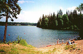
visitors excellent wilderness opportunities. 150 km (92 miles) west of
McBride is the Purden Lake Provincial Park, Purden Lake Resort and Purden
Ski Village. Air charter access to this area is available.
Prince
George:
Situated at the junction of the Fraser and Nechako Rivers, Prince George
was founded in 1807 by Simon Fraser. A regional centre for government
service, health care and post secondary education this large northern
city is located at the crossroads of the Yellowhead Highway and Highway
97 and the BC Rail and CNR Railways. As forestry as its main economic
stay, Prince George was first established with small sawmills and later
in 1964 a pulp mill.
Fort
George Park:
Located at the end of 20th Avenue, overlooking the Fraser, it's the original
site of the outpost built by Simon Fraser for the North West Company in
1807. Part of the park is the ancestral burial ground for the local Lheit-Li'ten
Nation. The Fraser-Fort George Regional Museum is located in the parkand
displays the city's economic development and natural history as well as
an old-time railway and historic buildings. The park is located at the
end of 20th Avenue.
Cottonwood
Island Nature Park:
Off River Road, it's a peaceful sanctuary with trails along the Nechako
River.
Prince
George Railway and Forest Industry Museum:
Near the
Cottonwood Island Park off of River Road is the museum. The history of
the Grand Trunk Pacific Railway (now the CNR) along with a complete station,
employee bunkhouses and restored railway cars may be viewed here.
Forests
for the World Park:
This park at the top of Cranbrook Hill offers hiking and cross country
trails through soft- and hardwood forests.
The Heritage
River Trail System:
Hike along the Fraser and Nechako Rivers to impressive viewpoints of the
area.
University
of Northern B.C. (UNBC):
Canada's newest university offers opportunities for study including First
Nations, environmental, international, northern and women's studies.
The following BC Adventure members would like to serve you:
Rocky Mountain Holidays: Rail Vacations in the Rocky Mountains & Western Canada! Rocky Mountain Holidays customize vacations that combine the romance of train travel with the magnificent scenery of Western Canada. more