BC ROCKIES: FERNIE TO SPARWOOD


Lodging & Services
Recreation
Cities & Towns
Lakes
Travel Info
Points of Interest
Provincial Parks
Trails


Fernie to Sparwood

Kootenay River

To visit the British Columbia Rockies continue from Cranbrook on Highway 3 and head northeast 
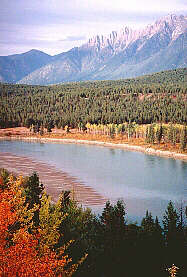
to Elko, Fernie, Sparwood and the Alberta border. From Elko to Sparwood you will travel through the Elk Valley, aptly named for the many herds of elk seen by early settlers. This region is unique as it is capable of supporting large populations of big game.

Fernie:
The town is named after William Fernie, who helped develop this area's coal mining. Fernie was established at the turn of the century when the railroad arrived. Legend has it that the founder, William Fernie, jilted an Indian maiden and in return her father placed a curse on the name 'Fernie'. Unfortunately events that followed are more real than legend... In 1902 an explosion in the mine killed 128 men. In 1904 and again in 1908, there were fires and floods. In 1964 it is said that Chief Red Eagle removed the curse.

Historic Oil Derrick and Drilling Equipment:
This equipment was used in Flathead Valley, near Fernie, from 1914 - 1920.

Heritage Buildings and Walking Tour:
Heritage buildings include the 1906 brick courthouse and the 1904 city hall.

Sparwood:
Located 28 km (18 miles) northwest of Fernie and 21 km (15 miles) from the Alberta border, Sparwood was established in 1966 to replace the towns of Natal and Michel which were to close to the mines and the coal dust the create. North from Sparwood is Elkford and Elk Lake Provincial Park.

The following BC Adventure members would like to serve you:
See The Rockies: Travel Guide to the Canadian Rockies. Map driving routes, explore Canada's Rocky Mountain National Parks, including Banff and jasper. Book lodging at hotels, resorts, guest ranches, and lodges. Plan sightseeing tours, outdoor adventures and more! more
Plan a Vacation
Lodging & Services: more info
Accommodations Adventures Attractions
Events Dining & Entertainment Shopping
Transportation Conference Centers Publications & Media
Recreation: more info
Attractions ATV Boating
Camping Canoeing & Kayaking Dog Sledding
Fishing Golf Guest Ranches
Health/Spas Cat & Heli-Skiing Hiking
Houseboating Mountain Biking Mountain Climbing
Multisport Natural Hot Springs River Rafting
Skiing Snowmobiling
Regional Information
Cities & Towns Lodging, Hotels, Services & Events . . more info
Lakes Resorts, Cabins, Fishing Info, Maps . . more info

Travel Info Travel Journals, Tourist Info Centers, Weather, Road Conditions, BC Ferries Info, Travel Planner . . more info

Points of Interest . . more info
Provincial Parks . . more info
Trails Hiking & canoeing trails . . more info

Area Maps of the BC Rockies
Junction of Hwys 3, 95 & 93:
Cranbrook & Area
Hwy 95 & 93 North from Cranbrook:
Kootenay River Invermere Columbia River
Golden Revelstoke - Rogers Pass
Central Kootenay Monashees (to Lumby)


Advertise With Us

Promote your business on the BC Adventure Network.
BC's largest and most visited tourism Web site . . . more info.

Advertising Inquiries:
advertising@ibcnetwork.com

© 1995 - 2018 Interactive Broadcasting Corporation


Follow Us On Facebook


List of BC Adventure
Advertisers

Site Info
Advertise With Us
Awards
About Us
Contact Us


Free Vacation Guides
BC Vacation Guides
Coastal Vacations
Thompson Okanagan
EcoTourism
Fishing Vacations
Guest Ranch Guide
Romantic Getaways
Wilderness Vacations
Winter Vacations
The Rockies Guide


Login


BC ROCKIES: FERNIE TO SPARWOOD